Welcome to Sustainable Environment Pty Ltd
Client: Victorian Local Government
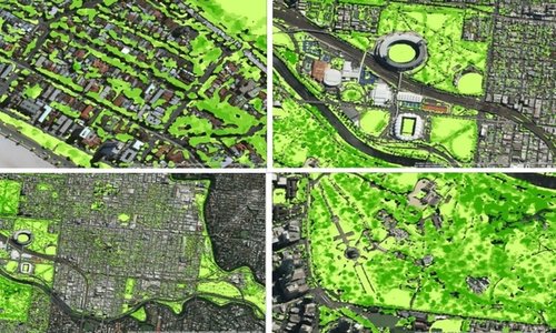
Sustainable Environment was engaged by The Nature Conservancy Australia (TNC) to provide spatial data management and remote sensing capabilities within the Urban Forest Strategy initiative across greater Melbourne. The release of the final report Living Melbourne marks the first urban forest strategy for the metropolitan Melbourne region.
Urban forest mapping and management has become an all-important feature of the urban environment and Sustainable Environment are proud to have delivered a key role in this project by generating a detailed vegetation dataset.
Sustainable's contribution to Living Melbourne consisted of management and review of satellite imagery and LiDAR rastar datasets. Mosaicking and automated clipping of rastar data was also performed, as well as further formatting and processing of both datasets. The data was then processed in Trimble eCognition software using an optimised workflow to create the final outputs.
The project was separated into three separate work packages.
Sustainable's contribution to this project has been well received by the client, and the outputs and data are being distributed to each of the councils for future use.
 Sustainable Environment
Sign up with your email address to receive news and updates.